Showing posts with label geophylogeny. Show all posts

Wednesday, June 24, 2015

Visualising Geophylogenies in Web Maps Using GeoJSON

Fig3 GoogleMaps CC BY no logo 300x205I've published a short note on my work on geophylogenies and GeoJSON in PLoS Currents Tree of Life:

Page R. Visualising Geophylogenies in Web Maps Using GeoJSON. PLOS Currents Tree of Life. 2015 Jun 23 . Edition 1. doi:10.1371/currents.tol.8f3c6526c49b136b98ec28e00b570a1e.
At the time of writing the DOI hasn't registered, so the direct link is here. There is a GitHub repository for the manuscript and code.

I chose PLoS Currents Tree of Life because it is (supposedly) quick and cheap. Unfortunately a perfect storm of delays in reviewing together with licensing issues resulted in the paper taking nearly three months to appear. The licensing issues were a headache. PLoS uses the Creative Commons CC-BY license for all its content. Unfortunately, the original submission included maps from Google Maps and Open Street Map (OSM), to show that the GeoJSON produced by my tool could work with either. Google Maps tile imagery is not freely available, so I had to replace that in order for PLoS to be able to publish my figures. At first I used simply replaced the tiles Google Maps displays with ones from OSM, but those tiles are CC-BY-SA, which is incompatible with PLoS's use of CC-BY. Argh! I got stroppy about this on Twitter:

Eventually I discovered maps from CartoDB that have CC-BY licenses, and so could be used in the PLoS Currents article. After replacing Google's and OSM tiles with these maps (and trimming off the "Google" logo) the figures were acceptable to PLoS. Increasingly I think Creative Commons has resulted in a mess of mutually incompatible licenses that make mashing up things hard. The idea was great ("skip the intermediaries" by declaring that your content can be used), but the outcome is messy and frustrating.

But, enough grumbling. The article is out, the code is in GitHib. Now to think about how to use it.

Thursday, January 22, 2015

GeoJSON and geophylogenies

For the last few weeks I've been working on a little project to display phylogenies on web-based maps such as OpenStreetMap and Google Maps. Below I'll sketch out the rationale, but if you're in a hurry you can see a live demo here: http://iphylo.org/~rpage/geojson-phylogeny-demo/, and some examples below.

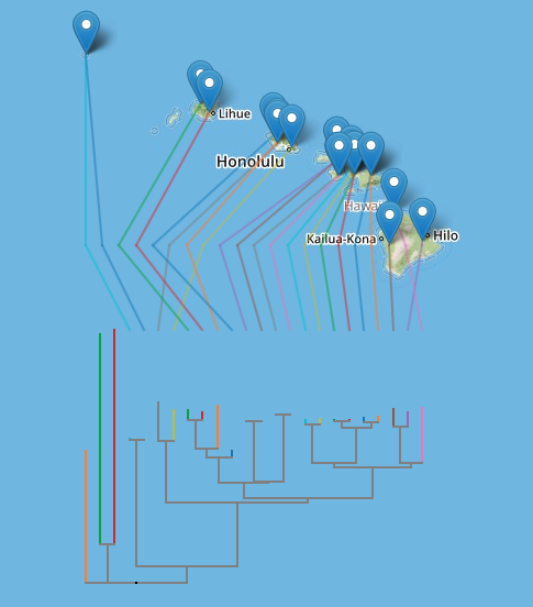
The first is the well-known example of Banza katydids from doi:10.1016/j.ympev.2006.04.006, which I used in 2007 when playing with Google Earth.

Banza

The second example shows DNA barcodes similar to ABFG379-10 for Proechimys guyannensis and its relatives.

Barcode

Background

People have been putting phylogenies on computer-based maps for a while, but in most cases these have required stand-alone software, such as Google Earth, or GeoJSON for encoding geographic information. Despite the obvious appeal of placing trees in maps, and calls for large-scale geophylogeny databases (e.g., do:10.1093/sysbio/syq043), computerised drawing trees on maps has remained a bit of a niche activity. I think there are several reasons for this:

  1. Drawing trees on maps needs both a tree and geographic localities for the nodes in the tree. The later are not always readily available, or may be in different databases to the source of phylogenetic data.
  2. There's no accepted standard for encoding geographic information associated with the leaves in a tree, so everyone pretty much invents their own format.
  3. To draw the tree we typically need standalone software. This means users have to download software, instead of work on the web (which is where all the data is).
  4. Geographic formats such as KML (used by Google Earth) are not particularly easy to store and index in databases.

So there are a number of obstacles to making this easy. The increasing availability of geotagged sequences in GenBank (see Guest post: response to "Putting GenBank Data on the Map"), especially DNA barcodes, helps. For the demo I created a simple pipeline to take a DNA barcode, query BOLD for similar sequences, retrieve those, align them, build a neighbour joining tree, annotate the tree with latitude and longitudes, and encode that information in a NEXUS file.

To layout the tree on a map (say OpenStreetMap using Leaflet or Google Maps) I convert the NEXUS file to GeoJSON. There are a couple of problems to solve when doing this.Typically when drawing a phylogeny we compute x and y coordinates for a device such as a computer screen or printer where these coordinates have equal units and are linear in both horizontal and vertical dimensions. In web maps coordinates are expressed in terms of latitude and longitude, and in the widely-used Web Mercator projection the vertical axis (latitude) is non-linear. Furthermore, on a web map the user can zoom in and out, so pixel-based coordinates only make sense with respect to a given zoom level.

To tackle this I compute the layout of the tree in pixels at zoom level 0, when the web map comprises a single "tile".

Tile

The tile coordinates are then converted to latitude and longitude, so that they can be placed on the map. The map applications take care of zooming in and out, so the tree scales appropriately. The actual sampling localities are simply markers on the map. Another problem is to reduce the visual clutter that results from criss-crossing lines connecting connecting the tips of the tree and the associated sampling localities. To make the diagram more comprehensible, I adopt the approach used by GenGIS to reorder the nodes in the tree to minimise the crossings (see algorithm in doi:10.7155/jgaa.00088). The tree and the lines connecting it to the localities are encoded as "LineString" objects in the GeoJSON file.

There are a couple of things which could be done with this kind of tool. The first is to add it as a visualisation to a set of phylogenies or occurrence data. For example, imagine my "million barcode map" having the ability to display a geophylogeny for any barcode you click on.

Another use would be to create a geographically indexed database of phylogenies. There are databases such as CouchDB that store JSON as a native format, and it would be fairly straightforward to consume GeoJSON for a geophylogeny, ignore the bits that draw the tree on the map, and index the localities. We could then search for trees in a given region, and render them on a map.

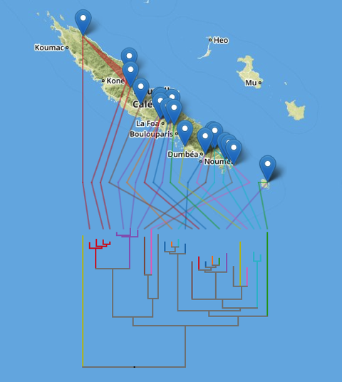
There's still some work to do (I need to make the orientation of the tree optional and there are some edges case that need to be handled), but it's starting to reach the point when it's fun just to explore some examples, such as these microendemic Agnotecous crickets in New Caledonia (data from doi:10.1371/journal.pone.0048047 and GBIF).

Cricket

Tuesday, February 21, 2012

Linking GBIF and Genbank

As part of my mantra that it's not about the data, it's all about the links between the data, I've started exploring matching GenBank sequences to GBIF occurrences using the specimen_voucher codes recorded in GenBank sequences. It's quickly becoming apparent that this is not going to be easy. Specimen codes are not unique, are written in all sorts of ways, there are multiple codes for the same specimen (GenBank sequences may be associated with museum catalogue entries, or which field or collector numbers).

So why undertake what is fast looking like a hopeless task? There are several reasons:
  1. GBIF occurrences have a unique URL which we could potentially use as a unique, resolvable identifier for the corresponding specimen.
  2. Linking GenBank to GBIF would make it possible for GBIF to list sequences associated with a specimen, as well as the associated publication, which means we could demonstrate the "impact" of a specimen. In the simplest terms this could be the number of sequences and publications that use data from the specimen, more sophisticated approaches could use PageRank-like measures, see hdl:10101/npre.2008.1760.1.
  3. Having a unique identifier that is shared across different databases makes it easier to combine data from different sources. For example, if a sequence in GenBank lacks geographic coordinates but the voucher specimen in GBIF is georeferenced, we can use that information to locate the sequence in geographic space (and hence build geophylogenies or add spatial indexes to databases such as TreeBASE). Conversely, if the GenBank sequence is georeferenced but the GBIF record isn't we can update the GBIF record and possibly expand the range of the corresponding taxon (this was part of the motivation behind hdl:10101/npre.2009.3173.1.

As an example, below is the GBIF 1° density map for the frog Pristimantis ridens from GBIF, with the phylogeny from Wang et al.Phylogeography of the Pygmy Rain Frog (Pristimantis ridens) across the lowland wet forests of isthmian Central Americahttp://dx.doi.org/10.1016/j.ympev.2008.02.021 layered over it. I created the KML tree from the corresponding tree in TreeBASE using the tool I described earlier. You can grab the KML for the tree here.

Density

As we'd expect, there is a lot of overlap in the two sources of data. If we investigate further, there are records that are in fact based on the same specimen. For example, if we download the GBIF KML file with individual placemarks we see that in the northern part of the range their are 15 GBIF occurrences that map onto the same point as one of the terminal taxa in the tree.

Gbif

One of these 15 GBIF records (http://data.gbif.org/occurrences/244335848) is for specimen USNM 514547, which is the voucher specimen for EU443175. This gives us a link between the record in GBIF and the record in GenBank. It also gives us a URI we can use for the specimen http://data.gbif.org/occurrences/244335848 instead of the unresolvable and potentially ambiguous USNM 514547.

If we view the geophylogeny from a different vantage point we see numerous localities that don't have occurrences in GBIF.

Nogbif

Close inspection reveals that some of the specimens listed in the Wang et al. paper are actually in GBIF, but lack geographic coordinates. For example the OTU "Pristimantis ridens Nusagandi AJC 0211" has the voucher specimen FMNH 257697. This specimen is in GBIF as http://data.gbif.org/occurrences/57919777/, but without coordinates, so it doesn't appear on the GBIF map. However, both the Wang et al. paper and the GenBank record for the sequence from this specimen EU443164 give the latitude and longitude. In this example, GBIF gives us a unique identifier for the specimen, and GenBank provides data on location that GBIF lacks.

Part of GBIFs success is due to the relative ease of integrating data by taxonomic names (despite the problems caused by synonyms, homonyms, misspellings, etc.) or using spatial coordinates (which immediately enables integration with environmental data. But if we want to integrate at deeper levels then specimen records are the glue that connects GBIF (and its contributing data sources) to sequence databases, phylogenies, and the taxonomic literature (via lists of material exampled). This will not be easy, certainly for legacy data that cites ambiguous specimen codes, but I would argue that the potential rewards are great.

Wednesday, February 08, 2012

Automating the creation of geophylogenies: NEXUS + delimited text = KML

One thing which has always frustrated me about geophylogenies is how tedious they are to create. In theory, they should be pretty straightforward to generate. We take a tree, get point localities for each leaf in the tree, and generate the KML to display on Google Earth. The tedious part is getting the latitude and longitude data in the right format, and linking the leaves in the tree to the locality data.

To help reduce the tedium I've create a tool that tries to automate this as much as possible. The goal is to be able to paste in a NEXUS tree, and a table of localities, and get back a KML tree. Some publishers are making it easier to extract data from articles. For example, if you go to a paper such as http://dx.doi.org/10.1016/j.ympev.2009.07.011 you will see a widget on the right labelled Table download.

Elsevier

If you click on the Find tables button you can download the tables in CSV format. In this case, Table 1 has latitude and longitude data for all the taxa in the tree in TreeBASE study S10103. With some regular expressions we can figure out which column has the latitude and longitude data, and parse values like (10°12′N, 84°09′W) to extract the numerical values for latitude and longitude.

It is also pretty straightforward to be able to read a tree in NEXUS format and extract the taxon names. At this point we have two sets of names (those from the tree and those from the table) which might not be the same (in this case they aren't, we have "Craugastor cf. podiciferus FMNH 257672" and "FMNH 257672"). Matching these names up by hand would be tedious, but as described in Matching names in phylogeny data files we can use maximum weighted bipartite matching to compute an optimal matching between the two sets of labels.

Create KML tree

You can try the Create KML tree tool at http://iphylo.org/~rpage/phyloinformatics/kml/.

To get started, try it with the data below. In step 1 paste in the NEXUS tree, in step 2 paste in the table from the original paper. If all goes as it should, you will see a table displaying the matching, and the KML which you can save and open in Google Earth. If you have the Google Earth Plug-in installed, then you should see the KML displayed on Google Earth in your web browser.


I've tested the tool on only a few examples, so there will be cases where it fails. It also assumes that every taxon in the tree has latitude and longitude values, and that the first column in the table is the taxon name (you'll need to edit the file if this is not the case).

Here is the tree used in the example...


#NEXUS
BEGIN TREES;
TRANSLATE
Tl254954 'Craugastor cf. podiciferus FMNH 257672',
Tl254956 'Craugastor cf. podiciferus FMNH 257653',
Tl254965 'Craugastor cf. podiciferus UCR 16356',
Tl254960 'Craugastor sp. A USNM 563039',
Tl254938 'Craugastor sp. A USNM 563040',
Tl254945 'Craugastor cf. podiciferus UCR 16360',
Tl254928 'Craugastor cf. podiciferus UCR 17439',
Tl254959 'Craugastor cf. podiciferus UCR 17462',
Tl254951 'Craugastor cf. podiciferus FMNH 257596',
Tl254967 'Craugastor sp. A FMNH 257689',
Tl254934 'Craugastor cf. podiciferus UCR 16355',
Tl254964 'Craugastor cf. podiciferus FMNH 257671',
Tl254963 'Craugastor cf. podiciferus UCR 16358',
Tl254952 'Craugastor cf. podiciferus UCR 18062',
Tl254926 'Craugastor cf. podiciferus UCR 17442',
Tl254968 'Craugastor sp. A FMNH 257562',
Tl254939 'Craugastor cf. podiciferus UCR 17441',
Tl254946 'Craugastor cf. podiciferus FMNH 257757',
Tl254942 'Craugastor cf. podiciferus MVZ 149813',
Tl254961 'Craugastor cf. podiciferus FMNH 257595',
Tl254969 'Craugastor cf. podiciferus UCR 17469',
Tl254932 'Craugastor cf. podiciferus MVZ 164825',
Tl254970 'Craugastor sp. A AJC 0891',
Tl254943 'Craugastor cf. podiciferus UCR 16357',
Tl254929 'Craugastor cf. podiciferus FMNH 257673',
Tl254950 'Craugastor cf. podiciferus FMNH 257756',
Tl254944 'Craugastor cf. podiciferus FMNH 257652',
Tl254953 'Craugastor cf. podiciferus UCR 16359',
Tl254931 'Craugastor cf. podiciferus UCR 17443',
Tl254940 'Craugastor stejnegerianus UCR 16332',
Tl254935 'Craugastor underwoodi UCR 16315',
Tl254958 'Craugastor cf. podiciferus UCR 16354',
Tl254966 'Craugastor sp. A AJC 0890',
Tl254949 'Craugastor cf. podiciferus FMNH 257758',
Tl254933 'Craugastor cf. podiciferus UCR 16361',
Tl254962 'Craugastor cf. podiciferus FMNH 257651',
Tl254948 'Craugastor cf. podiciferus FMNH 257670',
Tl254971 'Craugastor cf. podiciferus FMNH 257669',
Tl254936 'Craugastor cf. podiciferus FMNH 257550',
Tl254957 'Craugastor underwoodi USNM 561403',
Tl254947 'Craugastor cf. podiciferus FMNH 257755',
Tl254927 'Craugastor cf. podiciferus UCR 16353',
Tl254925 'Craugastor bransfordii MVUP 1875',
Tl254930 'Craugastor cf. podiciferus UTA A 52449',
Tl254955 'Craugastor tabasarae MVUP 1720',
Tl254941 'Craugastor cf. longirostris FMNH 257678',
Tl254937 'Craugastor cf. longirostris FMNH 257561' ;
TREE 'Fig. 2' = ((Tl254955,(Tl254941,Tl254937)),(((((Tl254954,Tl254942,Tl254933,Tl254948,Tl254971),((Tl254934,Tl254958,Tl254927),((Tl254964,Tl254929),Tl254930))),(((Tl254965,(Tl254963,Tl254943)),(Tl254959,Tl254969),(Tl254951,Tl254961)),((Tl254928,Tl254926,Tl254939,Tl254931),(Tl254952,Tl254932)))),((((Tl254956,Tl254936),Tl254946,Tl254950,(Tl254944,Tl254962),Tl254947),Tl254949),(Tl254945,Tl254953))),((((Tl254960,Tl254938),(Tl254970,Tl254966)),(Tl254967,Tl254968)),((Tl254940,Tl254925),(Tl254935,Tl254957)))));
END;


...and here is the table:


Taxon and institutional vouchera,Locality ID,Collection localityb,Geographic coordinates/approximate location,Elevation (m),GenBank accession number12S,16S,COI,c-myc
1. UTA A-52449,1,"Puntarenas, CR","(10°18′N, 84°48′W)",1520,EF562312,EF562365,None,EF562417
2. MVZ 149813,2,"Puntarenas, CR","(10°18′N, 84°42′W)",1500,EF562319,EF562373,EF562386,EF562430
3. FMNH 257669,1,"Puntarenas, CR","(10°18′N, 84°47′W)",1500,EF562320,EF562372,EF562380,EF562432
4. FMNH 257670,1,"Puntarenas, CR","(10°18′N, 84°47′W)",1500,EF562317,EF562336,EF562376,EF562421
5. FMNH 257671,1,"Puntarenas, CR","(10°18′N, 84°47′W)",1500,EF562314,EF562374,EF562409,None
6. FMNH 257672,1,"Puntarenas, CR","(10°18′N, 84°47′W)",1500,EF562318,None,EF562382,None
7. FMNH 257673,1,"Puntarenas, CR","(10°18′N, 84°47′W)",1500,EF562311,EF562343,EF562392,None
8. UCR 16361,3,"Alejuela, CR","(10°13′ N, 84°22′W)",1930,EF562321,EF562371,EF562375,EF562431
9. UCR 16353,4,"Heredia, CR","(10°12′N, 84°09′W)",1500,EF562313,EF562349,None,EF562420
10. UCR 16354,4,"Heredia, CR","(10°12′N, 84°09′W)",1500,EF562315,EF562363,None,EF562418
11. UCR 16355,4,"Heredia, CR","(10°12′N, 84°09′W)",1500,EF562316,EF562366,None,EF562419
12. UCR 18062,6,"Heredia, CR","(10°10′N, 84°06′W)",1900,EF562302,EF562342,EF562395,None
13. UCR 17439,5,"Heredia, CR","(10°09′N, 84°09′W)",2000,EF562298,EF562341,EF562387,EF562427
14. UCR 17441,5,"Heredia, CR","(10°09′N, 84°09′W)",2000,EF562299,EF562345,EF562388,EF562429
15. UCR 17442,5,"Heredia, CR","(10°09′N, 84°09′W)",2000,EF562300,EF562337,EF562385,EF562422
16. UCR 17443,5,"Heredia, CR","(10°09′N, 84°09′W)",2000,EF562301,EF562340,EF562384,EF562428
17. UCR 17462,5,"Heredia, CR","(10°09′N, 84°09′W)",2000,EF562309,EF562355,EF562406,EF562440
18. UCR 17469,5,"Heredia, CR","(10°09′N, 84°09′W)",2000,EF562310,EF562334,EF562405,EF562414
19. MVZ 164825,7,"Heredia, CR","(10° 05′N, 84° 04′W)",2100,EF562303,EF562346,EF562381,EF562423
20. UCR 16357,8,"San José, CR","(10°02′N, 83°57′W)",1600,EF562306,EF562339,EF562400,EF562433
21. UCR 16358,8,"San José, CR","(10°02′N, 83°57′W)",1600,EF562307,EF562370,EF562412,EF562415
22. UCR 16356,8,"San José, CR","(10°01′N, 83°56′W)",1940,EF562308,EF562329,None,None
23. UCR 16359,10,"San José, CR","(9°26′N, 83°41′W)",1313,EF562297,EF562369,EF562396,None
24. UCR 16360,10,"San José, CR","(9°26′N, 83°41′W)",1313,EF562296,EF562368,None,EF562434
25. FMNH 257595,9,"Cartago, CR","(9°44′N, 83°46′W)",1600,EF562304,EF562338,EF562408,None
26. FMNH 257596,9,"Cartago, CR","(9°44′N, 83°46′W)",1600,EF562305,EF562335,None,EF562416
27. FMNH 257550,11,"Puntarenas, CR","(8°47′N, 82°59′W)",1350,EF562294,EF562330,EF562393,EF562443
28. FMNH 257651,11,"Puntarenas, CR","(8°47′N, 82°59′W)",1350,EF562291,EF562367,EF562402,EF562435
29. FMNH 257652,11,"Puntarenas, CR","(8°47′N, 82°59′W)",1350,EF562288,EF562364,EF562390,None
30. FMNH 257653,11,"Puntarenas, CR","(8°47′N, 82°59′W)",1350,EF562292,EF562354,EF562392,EF562438
31. FMNH 257755,11,"Puntarenas, CR","(8°46′N, 82°59′W)",1410,EF562289,EF562344,EF562379,None
32. FMNH 257756,11,"Puntarenas, CR","(8°46′N, 82°59′W)",1410,EF562290,EF562347,EF562377,EF562413
33. FMNH 257757,11,"Puntarenas, CR","(8°46′N, 82°59′W)",1410,EF562293,EF562352,EF562383,EF562437
34. FMNH 257758,11,"Puntarenas, CR","(8°46′N, 82°59′W)",1410,EF562295,EF562348,EF562397,EF562436
35. USNM 563039,12,"Chiriquí, PA","(8°48′N, 82°24′W)",1663,EF562284,EF562356,EF562389,EF562445
36. USNM 563040,12,"Chiriquí, PA","(8°48′N, 82°24′W)",1663,EF562285,EF562350,EF562391,EF562439
37. AJC 0890,12,"Chiriquí, PA","(8°48′N, 82°24′W)",1663,EF562282,EF562351,EF562398,EF562444
38. MVUP 1880,12,"Chiriquí, PA","(8°48′N, 82°24′W)",1663,EF562283,EF562358,EF562399,EF562442
39. FMNH 257689,12,"Chiriquí, PA","(8°45′N, 82°13′W)",1100,EF562287,EF562353,EF562407,EF562446
40. FMNH 257562,12,"Chiriquí, PA","(8°45′N, 82°13′W)",1100,EF562286,EF562357,EF562410,EF562441
41. USNM 561403,N/A,"Heredia, CR","(10°24′N, 84°03′W)",800,EF562323,EF562361,EF562378,None
42. UCR 16315,N/A,"Alejuela, CR","(10°13′N, 84°35′W)",960,EF562322,EF562362,EF562394,None
43. UCR 16332,N/A,"San José, CR","(9°18′N, 83°46′W)",900,EF562325,EF562360,EF562411,AY211320
44. MVUP 1875 fitzingeri group,N/A,"BDT, PA","(9°24′N, 82°17′W)",50,EF562324,EF562359,None,AY211304
45. MVUP 1720,N/A,"Coclé, PA","(8°40′N, 80°35′W)",800,EF562326,EF562332,EF562401,EF562424
46. FMNH 257561,N/A,"Chiriquí, PA","(8°45′N, 82°13′W)",1100,EF562327,EF562331,None,EF562426
47. FMNH 257678,N/A,"Chiriquí, PA","(8°45′N, 82°13′W)",1100,EF562328,EF562333,EF562404,EF562425